Place names, along with other urban symbols, were used as a tool of control over space in many African countries during the colonial period. This strategy was epitomised by the British, who applied it in Nairobi and other parts of Kenya from the late 1800s.
Very few African names were used on the urban landscape. This was a strategy to actively alienate the native Africans, who had little or no say in the city’s affairs. Spatially, colonial street names dominated the central part of the city, while African names were used mainly in the peripheral residential neighbourhoods.
In early colonial Nairobi, the population was composed mainly of three groups: British, Asians and indigenous Africans. Africans formed the bulk of the population. But they were the least represented socially, economically and politically. According to the 1948 Nairobi Master Plan for a Colonial Capital, the British were the smallest population – the city had 642,000 Africans compared to 10,400 Europeans in 1944 for instance – but they held the political and economic power, and they applied it vigorously in shaping the identity of the city.
This was reflected in the naming of streets and places and spatial organisation of the newly founded city with little consideration of its pre-colonial status. Streets, buildings and other spaces such as parks were predominantly named after the British monarchy, colonial administrators, settler farmers and businessmen, as well as prominent Asian personalities.
The spatial organisation resulted in segregation, as observed in the use of terms such as European Bazaar, Subordinates’ Quarters, Coolie Landhies (a term used pejoratively) and the Indian Bazaar. These terms were initially used to conceptualise space divisions. But they gradually became proper nouns that represented actual place names.
The goal of this research, co-authored with Frederic Giraut, a professor at the University of Geneva, was to analyse the different ways in which the British colonial government deliberately built and imprinted their different urban symbols, including monuments and names, on the landscape of Nairobi.
Our study concluded that the naming of streets, places and landmarks was used to show the political, ideological and ethnic dominance of the British. Street names, in particular, were an important part of the urban nomenclature and place identification system. They were also symbols of the social and political organisation of the city.
I have chosen four examples to illustrate how this played out in reality.
1. Street numbering of railway depot and campsite
The railway line between Kenya’s Mombasa port and Uganda was built by migrant Indian labourers, known then as coolies. In mid-1899, it reached Nairobi, at this time a swampy area used by the Maasai to graze their cattle. It was identified as a favourable site for a temporary railway depot. However, it soon became a permanent settlement, with the construction of the railway station and residential quarters for railway officers, subordinate workers and Indian labourers (who resided in Coolie Landhies). There was a definite separation of residential quarters based on rank, service and race.
In the 1899 Uganda Railway Plan for Staff Quarters obtained from the Nairobi Railway Museum, the only roads with actual names were Station and Workshop roads. The others were either numbered streets or avenues. The street numbering pointed to the functionality of the railway campsite.
2. A claim to city pioneership
Those recognised as the “true pioneers” in colonial Nairobi were British administrators, settler farmers and businessmen, as well as railway personnel. The top colonial administrator in Kenya was known as a commissioner which was later replaced by the title governor. The first British administrator was Arthur Henry Hardinge, between 1895 and 1900. Thirty governors or acting governors followed until independence in 1963. Streets and parks were named after these and other British administrators, settlers and officials. Prominent settlers include Lord Delamere and Karen Blixen.
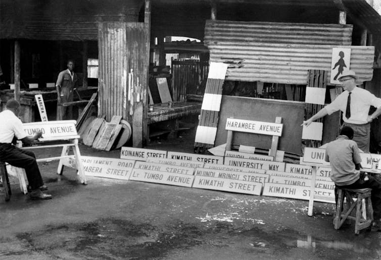
Sir Phillip Mitchell was the governor at the height of Kenya’s anti-colonial resistance. His term ended in 1952, the year a state of emergency was declared in Kenya. Mitchell Park along Ngong Road was named in his honour during the colonial period. It has since been renamed Jamhuri Park. Streets named after other “pioneers” included Sadler (now Koinange Street), Elliot (now Wabera Street) and Hardinge (now Kimathi Street).
Africans were relegated to mere manual labour and temporary residence in the city. The pioneers among them were not honoured. People such as Eliud Mathu (the first African member of the Legislative Council), Argwings Kodhek (Kenya’s first African lawyer), Harry Thuku (a prominent political activist) and Tom Mboya (who lobbied for African workers’ rights), among others, were only honoured through street and place names after independence.
3. Street names to honour the British political order
Visits to the Kenyan colony by members of the British royal family were much-anticipated events. The first such visit was by the Duke of Connaught and his family. Later, a street was named Connaught Road in their honour. This led to the renaming of many streets after royals, for example, Princess Elizabeth Way, Victoria Street, Kingsway and Queensway in Nairobi. As shown in the 1960 topo cadastral map of Nairobi, colonial street names dominated and were complemented by colonial statues and monuments, such as the statue of King George and Queen Victoria.
Laragh Larsen, a geographer, highlights the linkage between royal power, and political and economic power in the “re-placing” of urban symbols. She gives the example of the unveiling of British monarch Queen Victoria’s monument. This event was held in Jeevanjee Park, which was named as such after prominent Indian businessman Alibhai Mulla Jeevanjee. It was Jevanjee who donated the monument in allegiance to the British colonial government and the monarchy.
4. Place names to recreate a ‘British home’
A major impetus of the colonial officials for naming places in Nairobi was to create a home away from home. This is evidenced by the naming of streets after towns, villages and regions in the UK. Some of those names have endured on the urban landscape of Nairobi: Hurlingham, Lavington, Riverside, Spring Valley, Westlands, Parklands and Highridge, among others. It is clear that the recreation of a British spatial idyll was for the comfort of the colonial officials who appeared to not feel at home with local or indigenous place names, or just used their power to name places which they considered “unnamed”.
Conclusion
If there’s anything Kenya could learn, it is that a naming landscape should showcase unity in diversity. Streets should honour not just the political elite, but other personalities and events that make up society.
***
Melissa Wanjiru-Mwita, Lecturer, Technical University of Kenya
This article is republished from The Conversation under a Creative Commons license.